Breakthrough CAD Solutions You Need to Know for Coastal Water Management

Is your coastline prepared for what’s coming next? Coastal regions around the world are increasingly facing the brunt of climate change. From rising sea levels and coastal erosion to frequent flooding and the loss of natural ecosystems, these areas are becoming more vulnerable with each passing year. As communities and governments seek long-term, sustainable solutions to safeguard coastlines, Computer-Aided Design (CAD) is emerging as a powerful tool in building climate-resilient infrastructure. CAD Connect, a leader in advanced CAD services, is at the forefront of this transformation, offering precision-driven design solutions that help mitigate environmental risks while enhancing infrastructure performance.
By enabling detailed simulations, accurate planning, and efficient resource management, CAD has become essential in coastal engineering. Explore with us, how CAD is revolutionizing coastal water management and shaping the future of sustainable coastal development in this blog.
Understanding Coastal Challenges and the Need for Innovation
Coastal areas are increasingly vulnerable due to a combination of natural and human-induced factors. Rising sea levels, driven by the melting of polar ice and the thermal expansion of oceans, pose a constant threat to low-lying cities and islands. Coastal erosion, exacerbated by storm activity and urban development, is rapidly reshaping shorelines and endangering infrastructure. Additionally, extreme weather events such as cyclones and storm surges lead to catastrophic flooding, damaging homes, ports, and ecosystems.
Compounding these issues is the widespread degradation of natural coastal buffers like mangroves, wetlands, and coral reefs. These vital ecosystems once protected coastlines from the full force of ocean waves, but are now diminishing due to pollution, land reclamation, and climate shifts. Considering these mounting challenges, a novel approach to coastal planning and infrastructure is essential one that integrates technology, precision, and adaptability. This is where CAD becomes invaluable.
The Role of CAD in Coastal Infrastructure Design
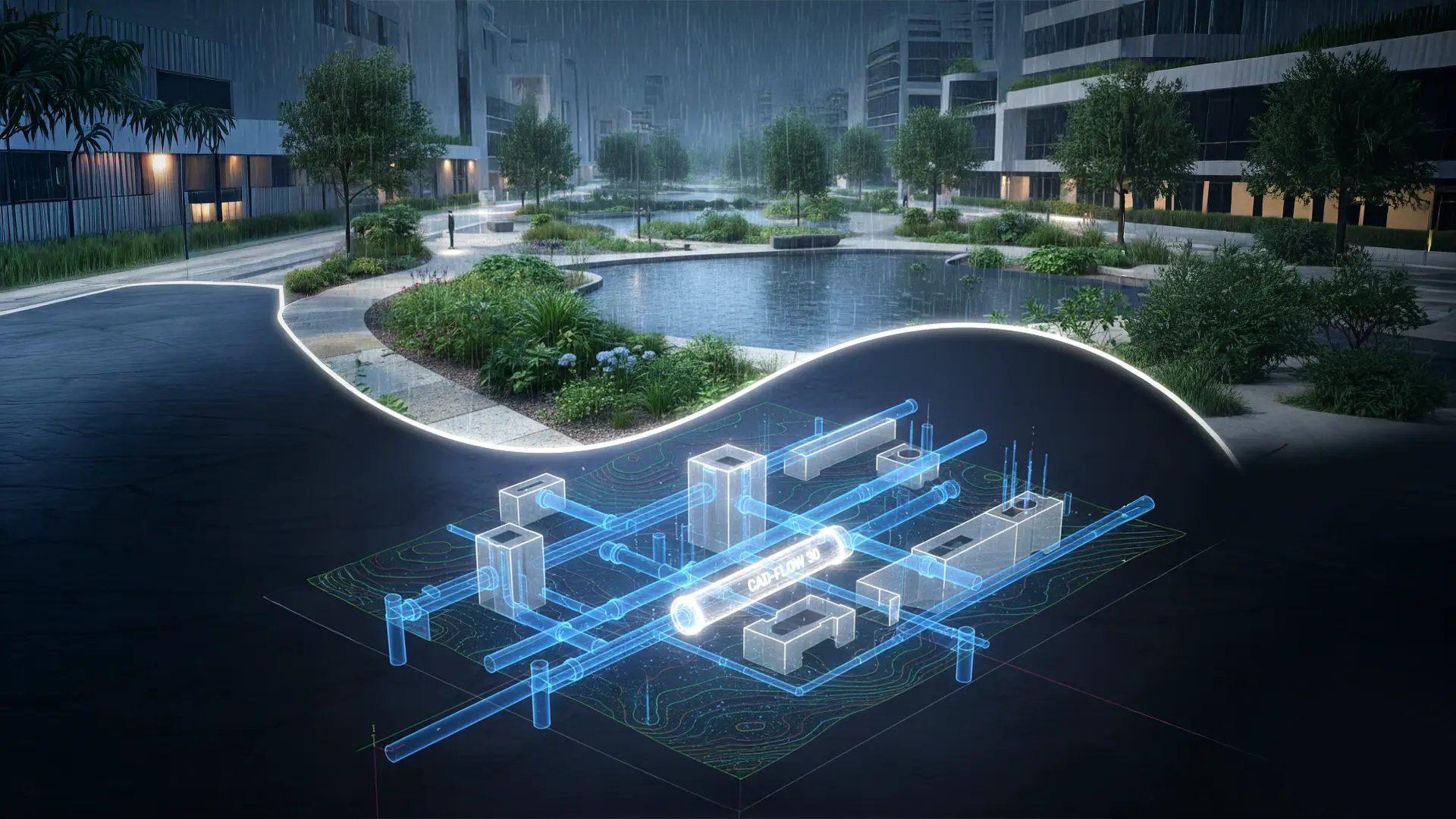
CAD is not just a drafting tool, it is a comprehensive design and planning platform that allows engineers to create, analyse, and optimize infrastructure before it’s physically built. In coastal water management, CAD is used to model structures like seawalls, levees, floodgates, drainage systems, and artificial reefs. These digital models provide visual insight into how structures will interact with terrain, tidal flows, and environmental forces.
Through 3D modelling and advanced simulation, CAD helps engineers understand coastal dynamics and assess the long-term performance of proposed solutions. CAD Connect specializes in harnessing these capabilities to develop customized coastal infrastructure that is both resilient and cost-effective. Their expert team creates detailed virtual layouts that account for shoreline geometry, sea-level projections, wave patterns, and other factors, ensuring that every project is tailored to the specific site conditions.
Simulation and Optimization with CADConnect
One of the most transformative aspects of CAD technology is its simulation capabilities. Before a single foundation is laid, engineers can use CAD to simulate how a seawall will withstand wave pressure during a storm surge or how a drainage system will perform under heavy rainfall. These simulations allow for early error detection, significantly reducing costly design revisions and construction delays.
CADConnect takes this further by offering advanced digital simulations that help clients optimize performance while minimizing environmental and financial costs. By testing multiple design iterations in virtual environments, CAD Connect ensures that every aspect of the coastal system is calibrated for efficiency, safety, and durability. This data-driven approach enhances confidence in project feasibility and outcome.
GIS Integration and Site-Specific Precision
A major strength of CAD in coastal engineering lies in its integration with Geographic Information Systems (GIS). By combining spatial data with engineering design, CADConnect can create context-aware models that factor in elevation data, soil composition, flood risk zones, and ecological sensitivity. This integration allows for more informed decision-making, especially in large-scale coastal planning.
GIS-enabled CAD tools help map vulnerable areas, prioritize intervention zones, and visualize potential impact areas. With the help of real-world data, CAD Connect designs infrastructure that fits the natural landscape rather than disrupting it. Whether it is designing a harbour with minimal environmental impact or planning flood defences for an urban coastline, CAD Connect ensures that spatial context is always at the forefront of the design process.
Sustainability Through Smart Design
Sustainable development is no longer optional., it is a necessity, especially for coastal regions already under pressure from environmental degradation. CAD Connect embraces this reality by promoting designs that conserve resources, protect ecosystems, and reduce carbon footprints. By using CAD to model low-impact solutions such as permeable flood barriers, energy-efficient pumping stations, and nature-based defence systems, CAD Connect helps clients achieve their sustainability goals without compromising functionality.
Moreover, CAD-based designs inherently support regulatory compliance, as detailed digital records can be used to demonstrate environmental impact assessments, design integrity, and adherence to local construction norms. With the increasing emphasis on climate adaptation and green infrastructure, CAD Connect’s expertise ensures that projects are not only environmentally sound but also future-proof.
Cost Efficiency and Return on Investment
While the initial setup for CAD systems and training may seem like a significant investment, the long-term financial benefits far outweigh the costs. CAD reduces errors, accelerates planning cycles, and limits material wastage, resulting in substantial cost savings throughout a project’s life cycle. In coastal water management, where errors can lead to severe consequences, this level of precision is crucial.
CAD Connect’s automated workflows and simulation-driven designs further enhance efficiency. By identifying the most cost-effective materials, optimal construction methods, and efficient layouts early in the process, CAD Connect helps clients stay within budget while achieving high-quality results. This leads to stronger returns on investment, particularly in large-scale infrastructure developments like ports, levee systems, and stormwater networks.
Engaging Stakeholders Through Visual Communication
Another advantage of CAD lies in its ability to foster better communication between stakeholders. Complex engineering concepts can be difficult for non-experts to understand, but CAD-generated visualizations and animations bridge this gap. With CAD, project teams can present detailed visuals to community members, government bodies, and investors, ensuring transparency and alignment at every stage.
This visual clarity helps accelerate approval processes, build public trust, and improve collaboration among architects, engineers, and environmental consultants. In projects that span years and involve multiple agencies, this clarity can be the difference between delays and successful, timely execution.
The Future of CAD in Coastal Resilience
Looking ahead, the role of CAD in coastal water management will only grow. As the technology evolves, we can expect further integration with AI and machine learning to improve predictive modelling for sea-level changes, erosion trends, and structural performance. Real-time collaboration platforms will allow stakeholders to co-develop and edit CAD models from anywhere in the world, reducing design timelines and increasing flexibility.
CAD Connect is committed to staying at the forefront of these advancements. By continuously upgrading tools, enhancing team capabilities, and prioritizing client collaboration, CAD Connect ensures that the most advanced and effective CAD solutions are available for modern coastal challenges.
Conclusion
Coastal resilience is no longer a distant goal, it is a pressing necessity. With the growing impact of climate change and environmental degradation, traditional methods of managing coastal risks are proving insufficient. Computer-Aided Design (CAD) is providing the precision, adaptability, and foresight needed to design smarter, more resilient infrastructure.
CAD Connect stands as a trusted partner in this mission. From detailed simulations and 3D modelling to GIS integration and sustainable design, CAD Connect empowers engineers, developers, and government bodies to build coastal systems that are durable, cost-effective, and environmentally sound. As the need for innovative coastal solutions continues to rise, CAD Connect’s expertise and technology-driven approach will be vital in safeguarding coastlines for generations to come.
Reach out to CAD Connect today to learn how our design solutions can help you build the future of coastal resilience.